You have no items in your shopping cart.
RSS

Blog

How to Choose the Right Surveying Equipment for Your Small Business: A Comprehensive Guide

Surveying is a fundamental process in various industries from construction to telecommunications, mining and environmental studies. It helps in understanding the terrestrial or three-dimensional space to plan, design and establish property boundaries. For small businesses operating in such sectors owning the right surveying equipment is crucial for providing accurate, efficient and reliable services.

This article aims to help small business owners in choosing the most suitable surveying equipment for their needs. It will explore the basics of surveying, the importance of surveying equipment for small businesses, different types of equipment available and factors to consider when making a purchase. Additionally, it will delve into the decision between renting versus buying equipment and the critical questions to ask vendors when acquiring surveying tools.

Whether you are starting a new business or looking to upgrade your current equipment, this comprehensive guide will provide valuable insights to help you make informed decisions ensuring that you invest wisely in surveying equipment that can enhance your business's productivity and profitability.


Understanding the Basics of Surveying

Surveying, in its most fundamental form, is the science of determining the three-dimensional positions of points and the distances and angles between them. These points are often on the surface of the Earth and they're typically used to establish maps and boundaries for ownership or governmental purposes.

Surveying plays a crucial role in numerous fields such as construction, where it aids in the design and layout of buildings, roads, bridges and other infrastructure. In real estate it helps define property boundaries and in archaeology it enables the precise measurement of archaeological sites.


Different Types of Surveying

There are several types of surveying, each designed for specific applications:

  1. Land Surveying: This is one of the most common types of surveying used to establish land boundaries and topography for construction, mapping or legal purposes.
  2. Engineering Surveying: This type is used before, during and after construction projects to ensure structures are built accurately according to architectural plans.
  3. Geodetic Surveying: This involves measuring large areas of the Earth's surface and requires advanced techniques and instruments to account for the Earth's curvature.
  4. Hydrographic Surveying: This involves surveying bodies of water to determine their depth, topography and other features, often used in marine navigation and construction.
  5. Mining Surveying: This is used to map underground and surface mines to ensure safe and efficient extraction of minerals.

Accuracy in surveying is paramount. Precise measurements are crucial for various applications from ensuring a building is constructed correctly to establishing accurate land boundaries to prevent legal disputes. The right surveying equipment plays a significant role in achieving such accuracy. A slight error in measurement can lead to significant issues down the line highlighting the importance of investing in quality surveying tools.


Importance of Surveying Equipment for Small Businesses

Surveying equipment can be a significant investment for a small business but the benefits it offers can be substantial. Accurate, reliable and efficient surveying is critical for a wide range of industries and the right equipment can make all the difference.


How the Right Surveying Equipment Can Help Small Businesses

  1. Accuracy: Quality surveying equipment can offer unparalleled accuracy reducing the risk of costly mistakes and rework. This is especially important for small businesses where margins can be tight and mistakes costly.
  2. Efficiency: Modern surveying equipment can make surveying tasks more efficient saving time and resources. For instance GPS systems can provide real-time data while laser scanners can quickly capture detailed measurements.
  3. Competitive Advantage: Owning state-of-the-art equipment can give your business a competitive edge. You can offer a wider range of services and deliver results faster and more accurately than competitors using outdated or lower-quality equipment.


Common Types of Surveying Equipment

The type of surveying equipment required can vary significantly depending on the specific needs of your business. Here, we will discuss some of the most commonly used tools in the industry and their applications.

  1. GPS/GNSS Systems: These systems use signals from satellites to determine precise locations on the Earth's surface. They are especially useful for land and topographic surveying offering high accuracy and real-time data.
  2. Theodolites: A theodolite is a precision instrument for measuring angles in the horizontal and vertical planes. They are commonly used in building and infrastructure construction to ensure accurate alignment.
  3. Total Stations: A total station combines the functions of a theodolite with an electronic distance measurement device. They can measure distances, angles and elevations, making them extremely versatile for a wide range of surveying applications.
  4. Levels: Levels are used to determine relative height and distance between points. They are crucial in construction and engineering surveys where accurate height measurement is required.
  5. Laser Scanners: Laser scanners, or LiDAR systems, use laser light to capture detailed three-dimensional data. They are used for topographic surveys, architectural surveys and even in archaeology for detailed site documentation.


What Each Type of Equipment is Used For

  1. GPS/GNSS Systems: Ideal for large scale land surveys, mapping and in any situation where high accuracy positioning is required.
  2. Theodolites: Used in construction and engineering projects to provide precise measurements and ensure structures are built to specification.
  3. Total Stations: Used across multiple industries from construction and engineering to archaeology for their versatility in capturing both distance and angular measurements.
  4. Levels: Essential in construction, especially for determining elevation and verifying that structures are level.
  5. Laser Scanners: Used extensively in topographic and as-built surveys, heritage preservation, mining and more due to their ability to quickly capture high-resolution 3D data.

Understanding the various types of surveying equipment and their applications can help you determine which tools are most suited to your business needs. Remember, the right equipment for your business will depend on the types of surveys you will be conducting and the level of precision required.


Determining Your Surveying Needs

Before you can choose the right surveying equipment you need to have a clear understanding of your specific needs. This will depend on the nature of your business, the types of projects you handle and the level of precision required.

Your equipment needs will depend on the type of surveying your business specialises in. For example, if you're in the construction industry you might need a total station for its ability to measure angles and distances accurately. On the other hand if your business focuses on large-scale land surveys a high-precision GPS system might be more appropriate.

To identify your specific needs consider the following questions:

  1. What types of surveys does your business typically conduct?
  2. What level of precision is required for these surveys?
  3. How often will you be using the equipment?
  4. Will you be surveying in difficult weather conditions or challenging terrains that might require rugged equipment?
  5. Do you need equipment that can integrate with other tools or software you currently use?

The scope and complexity of your projects can also influence the type of equipment you need. For large complex projects you may need advanced equipment that can handle a wide range of surveying tasks. Smaller simpler projects may only require basic tools. Therefore it's essential to consider both your current and potential future project needs when selecting surveying equipment.

Remember, investing in the right surveying equipment is not just about meeting your current needs. It's also about preparing for future growth and opportunities. By carefully assessing your needs and considering the scope and complexity of your projects you can make a more informed decision and choose equipment that will serve your business well both now and in the future.


Factors to Consider When Choosing Surveying Equipment

Once you've identified your specific needs there are several other factors to consider when choosing the right surveying equipment for your business. These can help ensure that you make a wise investment that will benefit your business in the long run.


Budget Considerations

The cost of surveying equipment can vary widely, from a few hundred to several thousand dollars. Consider how much you're willing and able to invest and remember that while higher-priced equipment often offers more features and greater accuracy it may not always be necessary for your specific needs.


Equipment Reliability and Durability

Surveying can be a demanding job, often conducted outdoors in various weather conditions. Therefore, it's important to choose equipment that is durable and reliable. Look for equipment that is weather-resistant and has a good track record of performance in your industry.


Accuracy of the Equipment

Accuracy is paramount in surveying. The level of precision you need will depend on your specific surveying tasks. Be sure to choose equipment that meets or exceeds the level of accuracy required for your projects.


Ease of Use and Training Requirements

Some surveying equipment can be complex to use. Consider how easy it will be for you and your team to learn to use the equipment and the training courses available. Remember, time spent learning to use complicated equipment is time not spent on productive work.


Future-proofing and Scalability

Your business needs may evolve over time and the surveying equipment you choose should be able to accommodate this growth. Look for equipment that can be upgraded or expanded as your needs change.


Technical Support and Maintenance Services

Finally, consider what kind of support is available for the equipment. Is there technical support you can reach out to if you encounter problems? Are there maintenance services available to keep the equipment in top condition?

By taking these factors into consideration you can ensure that you choose the surveying equipment that is the best fit for your business's needs, both now and in the future.


Renting Vs. Buying Surveying Equipment

The decision between renting and buying surveying equipment is another crucial factor to consider. Both options come with their own sets of advantages and disadvantages, and the right choice depends on your specific situation.

Renting Equipment

Pros:

  • Flexibility: Renting allows you to use different equipment for different projects offering you the flexibility to adapt to varying needs.
  • Lower upfront costs: Renting eliminates the need for a large initial investment.
  • Maintenance and repairs: The rental company typically handles maintenance and repairs, saving you time and resources.

Cons:

  • Long-term cost: Renting can be more expensive in the long run if the equipment is used regularly.
  • Availability: The equipment you need may not always be available when you need it.

Buying Equipment

Pros:

  • Availability: When you own the equipment it's always available when you need it.
  • Long-term cost savings: While the initial cost can be high, owning the equipment can be more cost-effective over time if it is used frequently.
  • Potential for customization: Owning equipment allows for customization to suit your specific needs.

Cons:

  • Upfront costs: Buying equipment requires a significant initial investment.
  • Maintenance and repair responsibilities: When you own equipment you're responsible for maintenance and repairs which can be costly and time-consuming.

When deciding between renting and buying, consider the following:

  1. How often will you use the equipment?
  2. Can you afford the upfront cost of buying the equipment?
  3. Do you have the resources to maintain and repair the equipment?
  4. Does your work require flexibility in the types of equipment used?
  5. Are you comfortable with the risk of equipment becoming outdated?

Weighing these considerations can help you make an informed decision about whether to rent or buy your surveying equipment. Remember, the right choice will depend on the unique needs and circumstances of your business.


Questions to Ask Vendors When Purchasing Surveying Equipment

Engaging with vendors is a crucial part of the process when purchasing surveying equipment. Here are some important questions to ask that can help ensure you get the best value for your investment.


Inquiring About the Product

  1. What is the accuracy level of this equipment?
  2. How durable is this equipment? Can it withstand harsh weather conditions and rigorous use?
  3. How easy is it to use this equipment? What kind of training will my team need?
  4. Is this equipment scalable or upgradeable for future needs?


Understanding the Support and Services

  1. What kind of technical support do you provide? Is it available 24/7?
  2. What does the warranty cover, and how long does it last?
  3. Do you offer any maintenance or repair services? What do they cost?


Assessing the Vendor

  1. How long have you been in business, and can you provide references from other customers in my industry?
  2. How familiar are you with my industry's specific needs and challenges?
  3. What sets you apart from other vendors selling similar equipment?

By asking these questions you can gain a better understanding of both the equipment and the vendor helping you make a more informed decision. It's important to choose not only the right equipment but also a reliable vendor who can provide the support and services you need to keep your equipment in top working condition.


Tips on Properly Maintaining and Storing Your Surveying Equipment

Maintaining and storing your surveying equipment properly is crucial to ensuring its accuracy, reliability and longevity. This section will guide you on the best practices for equipment care and how proper maintenance impacts the lifespan and accuracy of your surveying tools.


Best Practices for Equipment Care

  1. Regular Cleaning: After each use, clean your equipment to remove dirt, dust,and moisture. Use a soft cloth or brush and avoid abrasive materials that could scratch or damage the equipment.
  2. Periodic Calibration: Regularly calibrate your surveying equipment to ensure its accuracy. The frequency of calibration will depend on the manufacturer's recommendations and how often you use the equipment.
  3. Timely Repairs: If your equipment is damaged or not working correctly get it repaired as soon as possible. Using damaged equipment can lead to inaccurate measurements and further damage.
  4. Protective Cases: Use protective cases for transporting and storing your equipment. These cases will protect the equipment from physical damage and harsh environmental conditions.
  5. Avoid Extreme Temperatures: Extreme heat or cold can affect the performance of your surveying equipment. Try to store it in a temperature-controlled environment.
  6. Battery Care: If your equipment uses batteries make sure to recharge or replace them as needed. Remove batteries if you're storing the equipment for an extended period to prevent leakage.


The Impact of Maintenance on the Lifespan and Accuracy of Equipment

Proper maintenance and storage can greatly impact the lifespan and accuracy of your surveying equipment.

  1. Longevity: Regular cleaning, proper storage and timely repairs can extend the lifespan of your equipment, making it a better investment in the long run.
  2. Accuracy: Calibration is essential for maintaining the accuracy of your equipment. Over time use and environmental factors can cause the equipment to lose its calibration leading to less accurate measurements.
  3. Reliability: Well-maintained equipment is more reliable. You're less likely to encounter unexpected problems or failures which can cause delays or inaccuracies in your work.
  4. Resale Value: If you decide to upgrade or sell your equipment in the future well-maintained equipment will have a higher resale value.

In conclusion, investing time and effort in properly maintaining and storing your surveying equipment will pay off in the long run helping you to maintain accuracy in your work, extend the life of your equipment and even save money by avoiding unnecessary replacements or repairs.


Conclusion

Choosing the right surveying equipment is a significant decision that can greatly impact the success and efficiency of your small business. From understanding the basics of surveying and the importance of having the right equipment to identifying your specific needs and factors to consider when choosing equipment, this guide has provided comprehensive insights to help you make an informed decision.

Whether you're starting a new business or looking to upgrade your current equipment it's essential to invest wisely in surveying tools that will enhance your productivity and profitability. Consider renting versus buying, ask the right questions when dealing with vendors and always keep in mind that the best surveying equipment for you is the one that fits your specific business needs and budget.

With careful planning and consideration you can choose equipment that will not only meet your current needs but also adapt to your future growth. Remember, the right equipment can provide you with the accuracy and efficiency necessary to stay competitive in your industry ultimately contributing to your business's success.

---

Explore HiTechniques' range of top-quality surveying equipment today to find the perfect fit that will drive accuracy, efficiency and success in your small business.

Laser Level Maintenance: Extend Lifespan and Ensure Accuracy

All tools require proper care and routine maintenance for them to work correctly, and laser levels are no different. They are precision instruments and will give many years of service if cared for properly and serviced regularly. Here are some points to remember to extend your laser level's life and accuracy.


Proper storage

  • Your instrument should always be stored and transported in its specially designed carrying case, which, in turn, should never be used as a temporary tool kit.
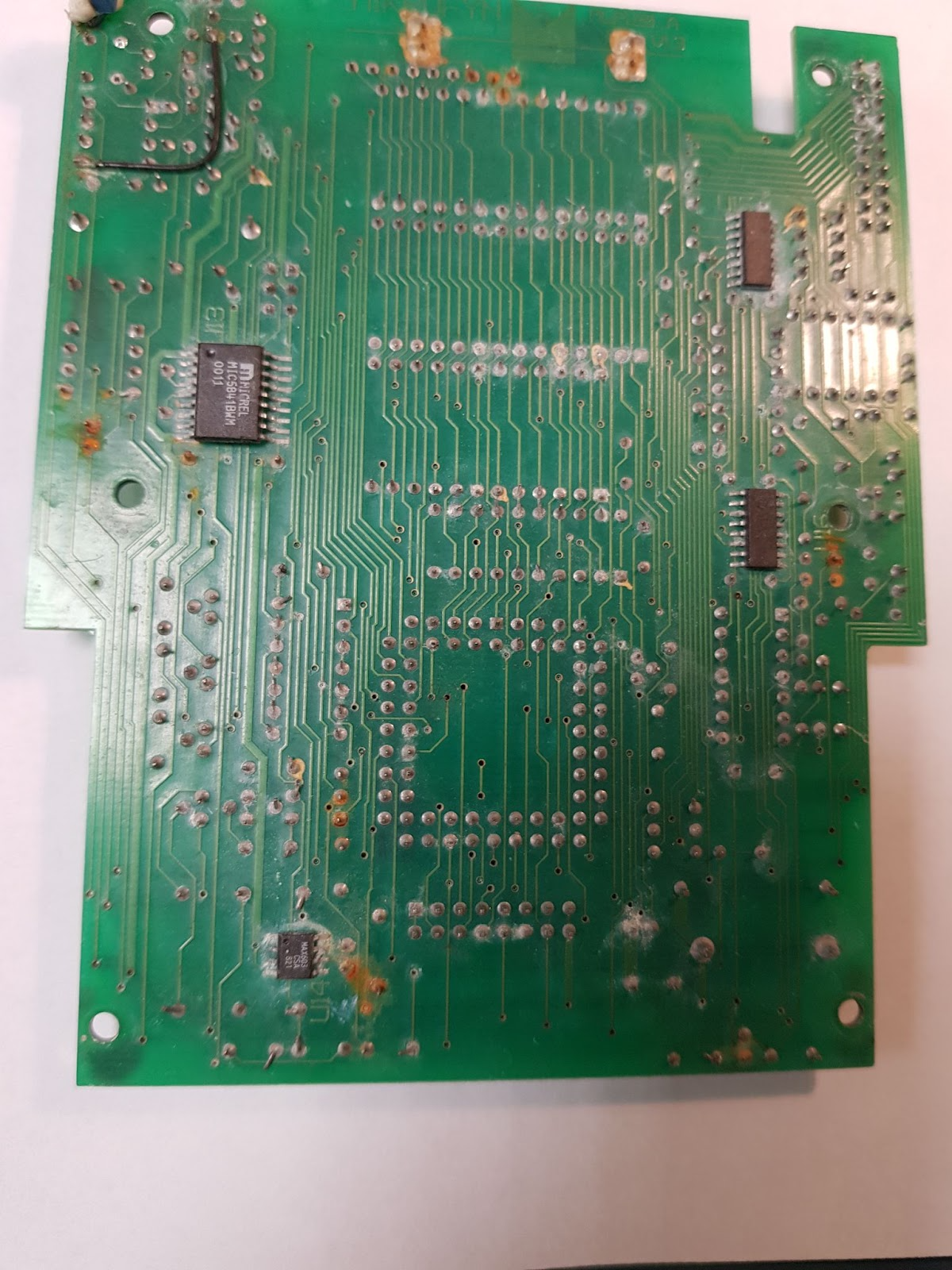
  • Moist instruments should be wiped dry before being put away. Damage caused by condensation is one of the biggest problems we encounter in our service department. A wet or damp instrument should never be stored in this condition. See the below picture for damage to the main PCB board due to the device being stored while still wet.

Cleaning 

  • lf the instrument is equipped with any kind of optical glass on the outside, these windows must be treated with care. When cleaning the glass, remember to always rinse it first with clean water and then dry it with a soft, clean cloth. Never use anything abrasive to clean the glass. If the glass surface gets scratched, the scratches may distort the laser beam and lead to incorrect readings.
  • Never clean with pressurized air, since dust particles in the air can lead to a "sand blasting" effect
  • lt is essential to keep plugs and clamps for electrical connections dry and clean as well.


Batteries and charging

  • Aways use a fully charged battery or power adapter. Charge the battery when the laser is not in use. If you notice that the battery is overheating during the charging process, you unplug it. Give it time to cool (20 minutes or so should be enough) and then plug it back in. Non-rechargeable batteries should be disposed of immediately after they deteriorate.
  • You should never carry a laser instrument by its cable, and a laser instrument should never be connected to a car battery that is still connected to a car.
  • When your instrument is not in use we recommend that you store it with the batteries removed from the instrument and accessories e.g. detector and remote control. If the batteries leak when the instrument is not in use for a prolonged amount of time they can cause a lot of unnecessary damage


Final thoughts

By following these few easy steps you can ensure longevity and accuracy of your instrument. Proper maintenance along with regular calibration will help you keep your instrument in good working condition. Take care when handling your laser and don’t skip yearly maintenance, so you can avoid any problems when tackling projects that require precision.

---

Need your laser calibrated? Get in touch with our Service Shop today!

The Importance of Ongoing Training for Surveying Equipment Users: What You Need to Know

Surveying equipment is a critical tool in many industries including construction, engineering, mining and land surveying. The equipment is used to measure and map land, structures and infrastructure providing essential information for project planning and development. For instance, in the construction industry alone, surveying equipment is used in 85% of all construction projects worldwide highlighting its importance.

However, the effectiveness of surveying equipment depends heavily on the knowledge and skills of the people using it. A survey by Trimble found that up to 50% of construction professionals lack adequate training in surveying equipment operation and maintenance indicating a significant knowledge gap in the industry. This gap can lead to inaccurate data, costly errors and even safety hazards on the job.

To address these issues, ongoing training for surveyors and construction engineers is crucial. By providing regular training and education, surveying equipment users can stay up-to-date with the latest technology and techniques which can improve accuracy, efficiency and safety on the job. Furthermore, ongoing training can help surveying equipment users maintain their certification and stay competitive in the job market.

In this article, we’ll explore the importance of ongoing training for surveying equipment users and the benefits it provides for accuracy, efficiency and safety on the job. We’ll also discuss common training methods, the importance of certification and provide examples of companies that have invested in ongoing training.


The Benefits of Ongoing Training

Ongoing training for surveying equipment users provides numerous benefits that can help improve the accuracy, efficiency and safety of surveying work.

Firstly, ongoing training helps improve the accuracy of surveying work by keeping users up-to-date with the latest technology and techniques. Surveying equipment is continually evolving and ongoing training ensures that users are aware of the latest advancements and how to use them correctly. This knowledge helps users to produce more accurate and reliable results which is essential in industries such as construction and engineering.

Secondly, ongoing training improves the efficiency of surveying work. By learning new techniques and tools surveying equipment users can perform their work faster and with greater precision. This can help to reduce the time required for data collection and analysis ultimately resulting in cost savings for the organisation.

Thirdly, ongoing training improves safety and reduces the risk of accidents on the job. Surveying work often involves working in hazardous environments such as construction sites, highways or railways. Proper training ensures that surveying equipment users are aware of the hazards and how to mitigate them. This knowledge can help to prevent accidents, injuries and even fatalities on the job.


Common Training Methods

There are several training methods available which include product-specific training, on-site training, online courses and workshops.

Product-specific training focuses on teaching users how to operate and maintain specific surveying equipment. Manufacturers often offer product-specific training to their customers either through on-site training or online courses. For example, Trimble offers a range of online courses on their Trimble Knowledge Center covering topics such as surveying workflows, data management and machine control.

On-site training involves a trainer visiting the organisation's site to provide training to the employees. The trainer may use the organisation's own surveying equipment to provide hands-on training. On-site training is convenient for organisations as it reduces the cost and time required to send employees to an external training facility.

Online courses are another popular training method for surveying equipment users. Online courses provide a convenient and flexible way for users to learn new skills and techniques. Users can access the courses from anywhere and at any time allowing them to fit training around their work and personal schedules. Trimble offers a range of online courses through their Trimble Knowledge Center, including courses on surveying workflows, data management, and machine control.

Workshops are another training method that is popular with surveying equipment users. Workshops are short, intensive courses that focus on specific topics or technologies. For example, Topcon Positioning Systems offers a range of workshops on topics such as total station operation, data collection and machine control. Workshops are typically conducted in small groups allowing for more personalised training. Workshops provide hands-on training and the opportunity to interact with other professionals in the field. However, workshops may require travel expenses and can be time-consuming.


Hitechniques Surveying Training Courses

To ensure proficiency with surveying equipment, it’s important to invest in training courses that teach specific skills and techniques. At Hitechniques we provide training as part of our customer care but also for individuals and groups that are interested in modern surveying methods. Our training offer includes:

  • GNSS/GPS Training Course 

Our GNSS/GPS Training Course is perfect for professionals who want to improve their RTK GNSS measurement skills, gain more site information and reduce their time spent in the office connecting dots. Taught by a former site engineer and lecturer at Trinity College, this course covers topics such as GPS fundamentals, field techniques and equipment troubleshooting. By the end of this course, you'll be more confident in using modern technology on site, completing jobs faster and increasing your revenue with better orders from contractors.

  • Total Station Training Course 

Our Total Station Training Course teaches you how to quickly set up the total station, station and orient, set out lines and levels for buildings, kerbs, manholes and gullies. You'll also learn how to use free-stationing to avoid obstacles when setting out, calculate areas and volumes and prepare drawings in AutoCAD. With our course, you'll be able to be more confident on the site and increase your efficiency in performing survey tasks.

Our Matterport 3D Capture Training Course, presented by a leading Matterport Service Provider in Ireland, teaches you how to use Matterport Capture technology to create immersive 3D models of any space. You'll also gain an understanding of uses and benefits of 2D floor plans, TruePlan and MatterPak data sets. With this course, you'll be able to tap into the full potential of 3D virtual tours and provide your clients with a better visual understanding of the surveyed space.

  • In-House & Bespoke Training Courses 

Our In-House & Bespoke Training Courses are designed to develop your team's surveying skills while building on their existing workplace experience. We offer tailored instrument courses, on-site setting out training specific to your needs, and advanced surveying courses for existing users. With our GNSS and Total Station training, your team will be able to set out and prepare drawings themselves, using the equipment you already have on site or can easily hire. By reducing the need to call survey companies for updates, queries, or adjustments, you'll save time and money while increasing efficiency.


The Cost of Ongoing Training

Despite the numerous benefits of ongoing training for surveying equipment users, some companies may be hesitant to invest in it due to the associated costs. Training can be expensive and some companies may not see the immediate benefits of investing in it. Additionally, training can take employees away from their work for a period of time which can result in lost productivity and additional costs for the organisation.

However, the cost of ongoing training can be outweighed by the many benefits. Investing in ongoing training can help companies to reduce the risk of errors and inaccuracies in their surveying work, which can save the company money by reducing the need for rework or revisions, which can be costly and time-consuming. For example, if a surveyor makes a mistake while conducting a land survey and the mistake is not detected until after construction has begun, it can cost the company thousands or even millions of euros to correct the error.

Investing in ongoing training can also improve the efficiency of surveying work reducing the time required for data collection and analysis. This can result in cost savings for the organisation as the same amount of work can be completed in less time. For example, if a surveying team can complete a project in two weeks instead of three weeks the organisation can save money on labour costs and other expenses associated with the project.

Finally, investing in ongoing training can improve safety and reduce the risk of accidents on the job. This can save the organisation money by reducing the costs associated with workplace injuries such as medical expenses, workers' compensation and lost productivity. For example, if a surveyor receives training on how to properly use safety equipment and prevent falls, the organisation can reduce the risk of injuries and avoid the associated costs.


The Importance of Certification

Certification is an important aspect of ongoing training for users worldwide. It demonstrates that a surveyor has the knowledge and skills necessary to perform their job safely and effectively. It also provides assurance to clients that the surveyor is qualified to perform the work required.

In Northern Ireland, surveyors must meet certain requirements to become licensed. To obtain a licence, surveyors must hold a degree in surveying or a related subject, complete two years of practical training, pass an exam and meet certain professional requirements. To maintain their licence, surveyors in Northern Ireland must complete a certain amount of continuing professional development (CPD) each year, which can be done through attending courses, workshops or conferences related to surveying.

In the EU, surveyors can obtain certification through organisations such as the European Federation of National Surveying Associations (FIG). FIG offers a range of professional qualifications and training courses for surveyors which can help them develop their skills and demonstrate their expertise to clients. By obtaining certification from organisations such as FIG, surveyors in the EU can differentiate themselves in the marketplace and demonstrate their commitment to their profession.


Conclusion

Ongoing training for surveying equipment users is crucial in ensuring accuracy, efficiency and safety in the workplace. While some companies may be hesitant to invest in training due to the cost, the benefits of improved performance and cost savings outweigh the initial investment. Certification is also essential for surveying equipment users, and ongoing training can help maintain certification requirements. It is vital that companies prioritise ongoing training for their surveying equipment users to stay up-to-date. Ultimately, investing in upskilling will lead to better outcomes for both the company and its employees.

Stay ahead in surveying: Invest in training today!

Efficiently Resolving Power On/Off Issues in Nedo Laser Model LINUS1 HV

Introduction

Nedo lasers are known for their precision and reliability, but occasionally, they may encounter power on/off issues. This article shares a practical approach to diagnosing and resolving such issues in the Nedo Laser Model LINUS1 HV without the need to send the unit back to the manufacturer for repair.


Initial Experience with Nedo Laser Repairs

A few months ago I faced a challenge with a Nedo laser that wouldn't rotate. After unsuccessfully attempting to fix it, I contacted the Nedo service centre in Germany. They suggested it might be a software issue and quoted a 60 Euro fee for a software update. With the customer's approval, we sent the unit to Germany for repair. However, Nedo's repair estimate was a surprising 700 Euros which led to the customer declining the service. This frustrating experience motivated me to find an alternative solution for future repairs.


Troubleshooting Power On/Off Issues

When I received another Nedo laser with a power on/off issue, I was determined to repair it myself or inform the customer that it was unrepairable. I began the diagnostic process by testing the battery which proved to be in good condition and not the cause of the problem.


Identifying and Resolving the Problem

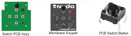
Upon further investigation, I found that the main switch PCB board was likely the culprit. I sourced a replacement PCB board from Nedo Germany for 15 Euros with a 30 Euro shipping fee. I then remembered that we had some push buttons in our old spare parts inventory which could be used for the repair. After locating the appropriate button, I replaced the faulty one on the PCB board, successfully repairing the laser.


Customer Satisfaction:

After reassembling the unit I contacted the customer to inform them that their equipment was fixed and ready for collection. They were pleasantly surprised to learn that I had repaired the laser at my service centre without the need to ship it to Germany. This efficient and cost-effective solution left the customer highly satisfied with the outcome.


Conclusion

By developing a thorough understanding of the Nedo Laser Model LINUS1 HV and its components, it is possible to diagnose and resolve power on/off issues effectively without relying on the manufacturer for repairs. This approach saves time, reduces costs and enhances customer satisfaction.

---

Need you laser calibrated or repaired? Get in touch with us today!

GPS vs GNSS: Technologies for Global Positioning and Navigation

We're going back to basics today with a quick explanation on what GPS and GNSS stand for, and which term should you use when referring to navigation systems.

The Global Navigation Satellite System (GNSS) is a collective term for satellite navigation systems that deliver autonomous geo-spatial positioning with global coverage. This umbrella term encompasses various systems including GPS, GLONASS, GALILEO, BEIDOU and other regional satellite constellations. The primary benefit of accessing multiple satellite systems is enhanced accuracy, redundancy and constant availability.

Although satellite systems rarely fail, GNSS receivers can switch to alternative systems if one is compromised or if the line of sight is obstructed. GNSS receivers are compatible with signals from any positioning satellite, not just those within the GPS system. As a result they offer more accurate and reliable positioning than GPS alone.


Is using the term GPS instead of GNSS incorrect?

People often use the term "GPS" instead of "GNSS" due to greater familiarity with GPS as a standalone system. Developed and maintained by the US government, GPS is part of the GNSS network catering to both military and civilian uses. It comprises a series of satellites and ground control stations that deliver precise location and timing data to users worldwide.

GNSS includes other satellite-based navigation systems such as GLONASS (Russia), Galileo (Europe), BeiDou (China) and QZSS (Japan). The primary objective of GNSS is to provide global location and navigation information to users.

The number of satellites in a system directly impacts the accuracy of the location information it provides. While GPS has 31 operational satellites, GLONASS has 24, Galileo has 30 and BeiDou has 35. GNSS, excluding the GPS constellation, has a total of 89 satellites, contributing to its superior accuracy compared to GPS alone. Nonetheless, the accuracy also depends on factors like receiver quality and the presence of interference or obstructions.


What's the main difference between GPS and GNSs systems?

GPS is widely available and reliable, finding applications in industries such as transportation, agriculture and recreation. However, signal jamming or interference can affect its availability and reliability. GNSS offers more robust availability and reliability by using multiple systems. If one system fails, users can still access location and navigation information from others which is especially useful in areas with limited or unreliable GPS coverage.

Initially developed for military use, GPS is now operated by the US Department of Defense for both military and civilian purposes. Other GNSS systems like GLONASS and BeiDou were also created for military use and are managed by their respective countries' armed forces, raising concerns about potential signal disruption or jamming during military conflicts.


It's all about accuracy

The future of GNSS and GPS technology continues to evolve with advancements aimed at improving accuracy, availability and functionality. One major development in the field is the integration of various GNSS systems to form a multi-constellation system providing even more accurate and reliable location and navigation information.

In summary, GNSS and GPS are satellite-based technologies that deliver location and navigation information to users. While GPS is widely available and affordable, GNSS offers more comprehensive coverage and accuracy through the use of multiple systems.

Unicontrol's Surfaces Function: Simplifying Earthworks with On-Machine Surface Creation

The team at Unicontrol have really thought about their product and the useability of that product for the end user, in this case, the operator of excavators, wheel loaders, dozers, backhoes and finally, their GNSS Rover.

One of my favourite features is the Create Surfaces function, which allows the operator to quickly create a level by themselves using the information given to them on the drawing.

The Create Surfaces feature can speed up the process onsite and reduce the need for the contractor or engineers to provide 3D surface drawings to enable the machine to work. The system is constantly upgrading and meeting the demands of the customers. There are currently four options for creating surfaces. Read below for a quick introduction to these options.


Flat Surface

This option enables the operator to create a flat or level surface at a given elevation. The elevation can be entered by the operator in the app. For example, if the site plans show a FFL (Finished Floor Level), the operator can use this information to create a surface at the given elevation without the need to have an engineer set up a benchmark for them.


Surface From Points

This option enables the operator to create a surface from pre-surveyed points. Once the operator selects the points, the system automatically triangulates them, forming a surface as an XML surface file.

A simple scenario may be that the machine is excavating a site to formation level and there is a deep cut but there is no surface file on the excavator for the slopes. Using the DXF (linework) drawing the operator can survey points along that line at the desired depth. After the first points are taken at dig level, they can then survey points at the top level, i.e. from the boundary or a line for the top of slope. Once these points are surveyed the operator can then create a surface using the points in the Surface From Points feature.

The surface created this way will give the operator a level to work from with the required slope. This will speed up the productivity of the excavator as the operator will be able to complete the job in 1 pass.


Foundation Outline

This option works similarly to the flat surface. The only difference is that Flat surface is infinite, so wherever we go the level will remain the same.

With foundation outline we log/survey the outline of the foundation of the building and we can limit the surface to a certain distance outside the footing extremities.

E.g. If the machine was working on a building site with different floor levels we can set the foundation outline for each house numbering them as we go, all surfaces will be saved in the history of the project in the jobs menu making it easy to revisit the surface again.


Cross Sectional Surface

This is a new function being released soon that will allow the operator to create simple road designs, ditches, etc. using polylines. This function will create a cross sectional view which will create the surface between the line work and for the length of the linework. It’s a real game changer for anybody using Unicontrol 3D.


Summary

Using machine control will usually boost productivity by 30-50%, allowing machine operators to work independently while reducing the need for a survey engineer.

The operator’s ability to create simple drawings really streamlines the earthmoving aspect on sites. Unicontrol’s surface generation feature boosts productivity even more as the operator can create surfaces of any shape or form independently and accurately, and complete the work in the first pass.

Earthworks should be simple and Unicontrol is making sure that their machine control systems make it possible.

---

We are offering a free 1 month trial of Unicontrol systems. Get in touch with brian@hitechniques.ie to register your interest.

Dundalk Fabrications Streamlining Their Workflow with Zoom90 and X-PAD

Based in Coe's Road Industrial Estate, Dundalk Fabrication & Coatings Ltd. is a specialist engineering company specialising in mild steel and stainless steel fabrication. Their expert team of Design Engineers, Project Managers and Fabricators provides turn key solutions from design concepts for commercial construction projects.

We asked their Site Manager - Eddie McArdle - about their work and why they decided to go with GeoMax surveying equipment and X-PAD field software.


What were the biggest challenges that your design and site teams faced?

When we first contacted Hitechniques in September 2022 our plan was to take on the site surveying and set out ourselves at a higher level. Our biggest challenge was getting information to the design team from the site and back again. We needed a more efficient way to share information about existing structures to be tied into new build, dimensions, heights of existing building elements.


Why choose Hitechniques ?

We wanted a system that would cover everything from surveying the site and getting the design drawn on the area available, to overlaying back on the ground. It had to be reliable and tailored to our specific needs. Hitechniques was able to cater for this.

We booked into training with Philip after a consultation with Roch on what we needed to achieve. They asked us questions on our upcoming projects and they came up with a tailor made plan to match our needs. The course was a very good introduction with theory and practical knowledge of the robotic total station and surveying.

From there, we hired the unit to trial. Once we knew it was the right unit for us, we purchased the full kit. We knew we'll be using it in a majority of our work and Roch went through the different options and provided case studies on long term and short term use. Buying outright made sense both logistically and financially.


What instrument did you end up purchasing?

The Zoom 90 Robotic total station pack with X-PAD software was the setup recommended to us. It brought all we wanted into one programme and enabled us to use it on site and set out all our points from the designers AutoCAD file, which was crucial for us.

We were able to survey the site, record finish floor levels, survey existing structural steel members and their connections. We could relay all of this information back with speed and accuracy and trust our own drawings to set out the new elements.

The main benefit of having the Zoom 90 is that we can create our own workflow on site. Once we have the site control and our bearings set up we can revisit the site, set up using the control stations and pick up where we left off. The day of string lines and using tapes to set out our holding down bolts and building lines is now all wrapped up digitally in the Zoom 90 Robotic total station.


What would you tell people thinking of buying new surveying equipment?

We would highly recommend Hitechniques as a company where you can not only purchase state of the art equipment but to get back up and technical support from their experienced staff. Having that safety net makes a huge difference, especially at the beginning when you’re still getting used to the new equipment and software.

Repair or Replace: When to Fix Your Surveying Equipment & When to Upgrade

Construction and surveying instruments are often exposed to very harsh conditions. Even though they are made from rugged materials and manufactured to specific standards, they can still be damaged by elements, dropped accidentally or even get run over by a truck or excavator. They can also stop working due to some mechanical or electrical issue that occurs with age, or even missed software updates.

Replacing instruments like rotary lasers or surveying GNSS rovers can be expensive, so it’s always worth looking into repair options first. In most cases experienced technicians can get your equipment repaired and back to you with minimal downtime and at a significantly lower cost.

There are a few instances though, when repair is not a viable option. Each instrument coming to the Hitechniques Service Shop is inspected thoroughly, so our technicians can make a list of repairs needed and parts that will have to be replaced. When examining an instrument, they take into consideration three main factors that need to be thought-through, before deciding whether to go ahead with the repair: cost, effectiveness of the repair and the age of the equipment.


Cost

It’s our policy to send repair estimates to each customer before we start working on their equipment, to check if they are ok with the price. Generally we leave the final decision to the customer and proceed with the repair if that’s what they want to do. In some cases, though, the equipment is beyond economical repair and we recommend replacing it instead. This happens if the predicted cost exceeds 75% of the value of a new instrument.

One of our customers has five electronic theodolites they purchased from us. Unfortunately a few days ago one of the theodolite fell down while working and got damaged. The vertical disc of the instrument was completely broken, the chassis was badly jammed, and the vertical angle was no longer visible on the screen. The vertical drive was also not working and the tribrach was bent.


With that much damage the cost of repairs would have been significant and exceeding the 75% of a new instrument’s value. Our technician suggested purchasing a new instrument and offered the customer a discount, if they were to buy from our store. The customer agreed to this offer and purchased a new device from us.


Effectiveness

Surveying and measuring instruments are complex machines built to deliver specific results. They are used by professionals relying on their accuracy and have to perform perfectly. Serious damage to the internal mechanism or electronic components can compromise the instrument’s ability to take accurate measurements.

While most parts can be fixed or replaced, sometimes it’s not possible to assure the same level of efficacy. In such cases it’s best to replace the instrument to avoid costly mistakes.


Age of the instrument

Not every professional needs the latest technology and some hold on to their trusty GNSS receivers or laser levels for many years. There’s nothing wrong with that and it’s great to see so many instruments performing outstandingly for long periods of time. Unfortunately, when such instruments are in need of repair, it can be difficult to find replacement for damaged or worn out parts.


Some final thoughts

When it comes to surveying and measuring instruments, the environmentally friendly “repair instead of replace” approach isn’t always a viable option. Technology becomes obsolete quicker, making repairs harder and more expensive because of complexity of work and poor availability of parts. It also puts more pressure on users to upgrade their equipment in order to stay ahead of the competition. Each case needs to be assessed individually before a decision is made, to assure it makes sense financially and is the best course of action for you and your business.

Beausang Plant Hire Chooses GeoMax Zenith60 IMU GNSS Rover for Superior Performance

Beausang Plant Hire & Civil Engineering are a company based in Shanagarry North, County Cork. They specialise in residential projects using the insulated concrete framework.

Having previously hired units when needed in the past, Aaron and Thomas decided that it was time for a solution better suited for their workflow. Working on a new residential housing development, they were considering purchasing their own GPS rover unit.

After trialling three different brands to see which instrument would best fit their needs, they decided to go with the GeoMax Zenith60 IMU GNSS Rover. An on-site demonstration with our Technical Sales Expert - Roch - gave the team the perfect opportunity to try out the instrument along with the X-PAD surveying software, and they were impressed with its capabilities.

“The machine itself was superior to the others in terms of speed and usability, and offered the best signal by far at our site without the need for a base station”, says Aaron Beausang.


As many other customers, Aaron also appreciated Hitechniques dedicated support, which includes basic training on the equipment and unlimited technical support provided by our experts.

“Hitechniques team offered great support anytime we needed it when getting started with the new kit. I would highly recommend Hitechniques and GeoMax to anyone looking for a great product and equally good support.”

Beausang Plant Hire & Civil Engineering are continuously investing in new equipment to ensure highest quality and accuracy of work for their customers. When they decided to #switchtogeomax our team helped them pick the right surveying solution, and now we look forward to seeing their business grow.

---

Interested in learning more about GeoMax surveying instruments and software? Get in touch with us today.


Unicontrol3D Machine Control - System Overview

Machine control is fast becoming a must have in the construction industry, increasing uptime and productivity by up to 50%. Machine operators don’t have to read the stakes visually anymore, they have the plans uploaded to a tablet right in front of them. 3D machine control uses tracking sensors and a receiver to get signal from satellites for positioning, enabling operators to put the bucket within 20 mm accuracy.

Unicontrol's 3D excavator, wheel loader and dozer machine control systems are relatively new to the Irish market. That being said, on a global platform Unicontrol already has 79 distributors across 26 countries, and over 1500 systems in operation. They are rapidly gaining recognition in the industry thanks to the user friendly, reliable system created with the operator in mind. Read below about what Unicontrol offers.


Noteworthy features of Unicontrol3D

  • Four constellations as standard

While some competitors only use GPS and GLONASS, Unicontrol systems always have 35 to 45 correction satellites at their disposal. The system uses GPS, GLONASS, BeiDou and Galileo, making it easier to get a fixed position in harsh environments.

  • Easy to use interface

Unicontrol3D with only 6 control buttons allows you to control your system without looking through drop down or hidden menus. every function is easily accessible and the software is highly intuitive, meaning that it can be used with only a minimal training. The software runs on a portable Samsung Android 8” rugged tablet, with a 10” also available.

  • Heavy duty sensors and cabling

Unicontrol heavy duty sensors and cabling are designed with military grade materials.

  • Fast acting IMU sensors

The sensors continuously track the machine’s movements in real time, ensuring highly accurate work each time. Unicontrol3D supports the articulated body, front arm and bucket sensors for wheel loaders as well as tilt rotator, swing- and dual boom for excavators.


  • DXF and LandXML data formats support

Drawing requirements of the system are DXF for linework and LandXML for 3D surfaces.

  • Can be used without GPS

Unicontrol3D will work if there’s no satellite signal available, making it a 2D system for simple excavations or grading. For example if working inside in a building like a warehouse where the roof is already on, the satellites could not see the machine. The system would work as 2D and allow the operator to grade out the area to the desired level.

  • Surfaces functionality

With Unicontrol3D you can create surfaces from the machine, which means that there is no need for expensive 3D CAD software. For example, if the machine is working on a housing scheme the operator can create a simple level/flat surface from the cab of the machine. All he/she needs to do is to simply input the elevation they desire to work to. Let’s say the FFL of the house is 11.45m (elevation above sea level) and the build-up is determined by the engineer to be 0.5m. The operator could create a surface for formation level by entering the elevation value of 10.95 (11.45 – 0.5 = 10.95). The level that the site needs to be reduced to is set in less than 1 minute, and without the need of a surveyor installing a bench mark.


  • Slope creation

A brilliant feature for pipelines, storm, foul, drainage etc. Most drawings for pipelines only show the centre of manholes as points, with Invert level shown on the drawing.The operator can use 2 of these points and enter the invert level of each. The system will calculate the grade between the 2 points and it will put a helpline in place so the operator will have a straight line between the manholes.

  • Map out/survey functionality

Unicontrol’s software offers a feature allowing an operator to create his own simple drawings. Helplines can be drawn as straight lines or curved, Circles can be drawn using 2 points or 3, Points can be logged.

  • Unicontrol Cloud

Unicontrol offers a simple system for transferring data between the tablet and the site office. Thanks to their cloud you can easily upload and share project data, assign machines and create projects. Also any logged points or surveys taken by the machine are saved here in the As-built.

  • Remote access

Unicontrol3D allows you to grant remote access to the system. This allows support engineers to view the interface of the system and control the screen, so they can troubleshoot any issues quickly. This can also be used for training purposes.

  • Warranty for your piece of mind

Unicontrol offers 2 year warranty on all hardware, and 2 year software updates with purchase.


Why choose Unicontrol?

Unicontrol3D will save time and money. It is an adaptable system that can be installed on excavators ranging from 2 tons to 120 tons. Can also be fitted to swing booms generally found on mini/midi excavators or knuckle/offset, or city booms found on larger excavators, and supports tilt rotator attachments.

In the next article we will be talking about creating surfaces in detail but before the article I will post some video content on how to create the different surfaces namely Flat/level surface, surface from points, or the surface of a foundation outline.

Unicontrol 3D distributed in Ireland by Hitechniques and in the UK by our friends Surveytech.

---

If you’d like to know more, schedule an obligation-free demo or avail of our 1 month free trial offer. Contact our Machine Control Expert - Brian - at 086 011 1460 or brian@hitechniques.ie