
How to Optimise Your Use of Surveying Equipment: Best Practices for Greater Efficiency and Results
Posted by Roch Hanmore B.Sc.; Philip Hanrahan B.E., B. A., M.I.E.I. on 21st Aug 2024
Surveying equipment is crucial for accurate measurements and data collection in construction, land surveying, and various engineering fields. At Hitechniques, we understand the importance of precision and reliability in these instruments, which is why we offer top-quality products from renowned brands like GeoMax, Fotric, and LaserLiner. This article aims to guide you through best practices for optimising your use of surveying equipment to enhance efficiency and accuracy in your projects.
Understanding Your Surveying Equipment
Surveying equipment encompasses a variety of tools designed for specific tasks. Key types include:
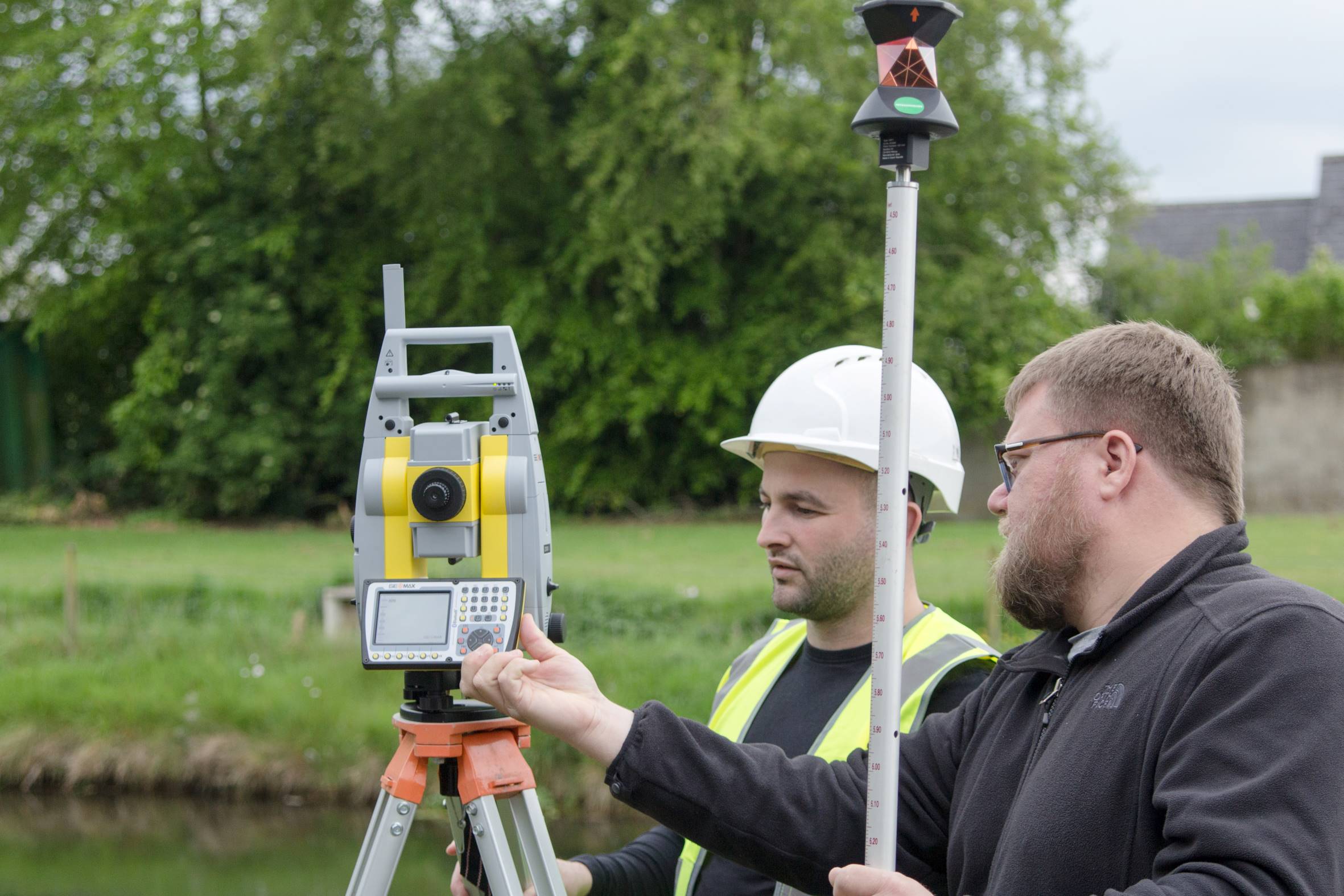
- Total Stations: Combining electronic distance measurement and angle measurement, Total Stations like those from GeoMax offer precise data collection for construction and engineering projects. These devices allow for detailed topographic surveys and layout works, critical for the precise placement of structures.
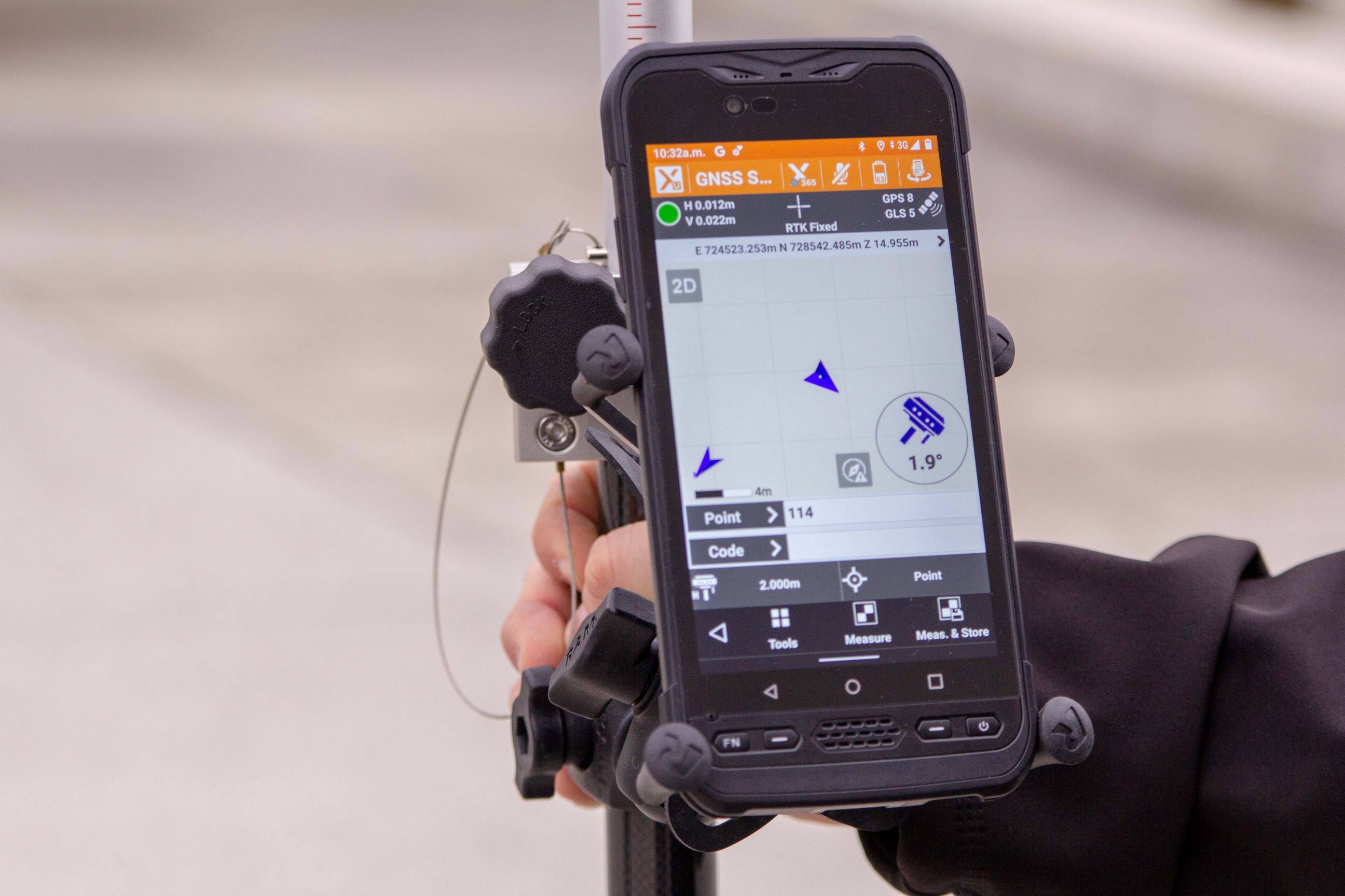
- GPS/GNSS Receivers: These devices use satellite signals to determine exact locations. GeoMax’s GNSS receivers provide high accuracy essential for surveying and mapping. RTK (Real-Time Kinematic) GNSS receivers can deliver centimetre-level precision, making them indispensable for boundary surveys and high-precision applications.
- Theodolites: Used for measuring horizontal and vertical angles, theodolites are vital for site layout and building construction. They are essential for tasks requiring angle measurements, such as laying out roads, pipelines, and buildings.
- Lasers and Levels: Laser levels from Leica and LaserLiner ensure accurate alignment and levelling, essential for various construction applications. For instance, rotary lasers can project level lines around a room, making them perfect for installing ceilings, floors, and cabinetry.
- Data Loggers: These devices record and store measurements taken by other surveying equipment, facilitating efficient data management. They can be integrated with other surveying tools to automate data collection processes and reduce the chances of manual errors.
Understanding the features and functionalities of these tools is fundamental. For instance, Total Stations offer integrated data management capabilities, while GPS receivers from GeoMax feature real-time kinematic (RTK) technology for enhanced precision. Laser levels provide different beam visibility options, such as high-visibility green lasers for outdoor use.
Proper Training and Knowledge
Proper training is essential for effective use of surveying equipment. At Hitechniques, we offer comprehensive training programs, including:
- GNSS/GPS Training Course: Learn the fundamentals and advanced techniques of GPS and GNSS technology. This course covers the principles of satellite positioning, field techniques for accurate data collection, and practical applications in various surveying tasks.
- Total Station Training Course: Gain hands-on experience with Total Stations, covering setup, operation, and data management. Training includes learning to operate different models, understanding their software, and integrating them with other surveying tools for comprehensive project management.
- Matterport 3D Capture Training: Explore the capabilities of 3D capture technology for detailed documentation and analysis. This training helps you understand how to create accurate 3D models of sites, which can be invaluable for planning and verification purposes.
Continuous learning is crucial. Regularly updating your knowledge through user manuals, data sheets, and online resources ensures you stay current with technological advancements. Hitechniques provides access to a wide range of resources, including instructional videos, user guides, and technical support.
Our in-house and bespoke training courses are tailored to meet specific needs, providing practical skills and insights into the latest equipment and methodologies.
Regular Maintenance and Calibration
Maintaining your surveying equipment is vital for accuracy and longevity. Establishing a routine for daily, weekly, and monthly maintenance tasks can prevent common issues. Here are some guidelines:
- Daily maintenance: Clean the equipment after each use, check batteries, and inspect for any visible damage or condensation. Ensure that all moving parts are free from debris and that lenses and sensors are clean. If the instrument is wet, dry it thoroughly before storing.
- Weekly maintenance: Perform a more thorough cleaning, test all functionalities, and ensure firmware is up to date. Check calibration settings and run diagnostic tests to identify any potential issues.
- Monthly maintenance: Conduct detailed inspections, including checking calibration settings and verifying accuracy against known standards. Lubricate moving parts if necessary and inspect electrical connections for wear and tear.
Calibration is equally important. Regular calibration ensures your equipment provides accurate measurements. At Hitechniques, we offer comprehensive calibration services for various instruments, including laser levels and GPS receivers. Our team provides expert calibration, ensuring your equipment meets industry standards and performs optimally. Neglecting calibration can lead to significant errors in data collection, affecting the quality and reliability of your survey results.
Accurate Data Collection Techniques
Accurate data collection is the cornerstone of successful surveying. Implementing best practices ensures the reliability of your measurements:
- Proper setup: Ensure your equipment is correctly set up and levelled. This includes calibrating your instruments and verifying their settings before use. Misalignment can lead to significant errors in your data.
- Environmental considerations: Be mindful of environmental factors such as weather conditions, which can affect measurements. Use appropriate accessories like tripods and stabilisers to minimise errors caused by environmental variables. For example, wind can cause vibrations that affect laser measurements, so using wind shields or choosing calmer times of day for certain tasks can improve accuracy.
- Systematic approach: Follow a systematic approach to data collection, ensuring consistency and accuracy. This includes methodically covering the survey area and double-checking measurements. For instance, taking multiple measurements and averaging them can reduce random errors.
- Use of technology: Employ technology such as data loggers and field computers to automate data collection and reduce human error. These tools can also integrate with software solutions for real-time data analysis and visualisation, enhancing decision-making on-site.
Avoid common mistakes such as neglecting calibration, misinterpreting data, and failing to account for environmental conditions. By adhering to best practices and using quality equipment from Hitechniques, you can minimise errors and enhance the precision of your data collection efforts.
Efficient Data Management and Processing
Efficient data management and processing are crucial for maximising the value of your survey data. Utilise data management systems to organise and store your measurements effectively. Software tools available at Hitechniques integrate seamlessly with your equipment, allowing for streamlined data processing and analysis.
- Data management systems: Use software such as GeoMax X-PAD to manage and process survey data. This software allows you to import data from various instruments, perform calculations, and generate reports. It also supports cloud storage, ensuring your data is accessible and secure.
- Integration with other systems: Check how to integrate your survey data with BIM (Building Information Modelling) and other systems for enhanced project efficiency. This integration enables better visualisation, coordination, and decision-making, ensuring your projects stay on track and within budget. For example, survey data can be used to create accurate 3D models in BIM software, facilitating better planning and collaboration among project stakeholders.
Proper data management ensures that your data is accurate, accessible, and usable when needed. It also helps in maintaining data integrity and preventing data loss, which is critical for long-term project success.
Advanced Techniques and Technologies
Staying abreast of emerging technologies and advanced techniques can significantly enhance your surveying practices. Some of the latest advancements include:
- 3D Capture Solutions: Matterport’s 3D capture technology offers detailed visual documentation, useful for site inspections and project planning. This technology allows you to create accurate 3D models of interiors and exteriors, providing a comprehensive view of the project site. These models can be shared with clients and stakeholders, improving communication and collaboration.
- Machine Control Systems: Integrating machine control systems with your surveying equipment improves accuracy and efficiency in construction projects. Unicontrol3D offers advanced solutions that streamline workflows and enhance productivity. Machine control systems automate the movement of construction machinery based on precise data, reducing the need for manual adjustments and increasing operational efficiency.
- RTK Technology: Real-time kinematic (RTK) technology in GPS receivers provides high-precision positioning, essential for tasks requiring exact measurements. RTK systems use corrections from a base station to improve the accuracy of GPS measurements, making them suitable for high-precision applications such as land surveying, construction staking, and agricultural mapping.
Hitechniques offers a range of innovative products incorporating these technologies. By adopting these advanced tools and techniques, you can stay competitive and achieve superior results in your surveying projects.
Fieldwork Best Practices
Effective fieldwork requires meticulous preparation and execution. Here are some best practices to enhance on-site efficiency:
- Preparation and planning: Conduct a thorough site assessment and ensure you have all necessary equipment and accessories. Check weather forecasts and plan your work accordingly. Having a clear plan reduces downtime and improves productivity.
- On-site efficiency: Use efficient workflows and leverage tools like LaserLiner distance metres and GeoMax locators for quick and accurate measurements. Ensure all team members are familiar with the equipment and their roles. This coordination helps avoid mistakes and ensures smooth operations.
- Safety considerations: Prioritise safety by wearing appropriate protective gear and following safety protocols. Ensure your equipment is securely set up and handled with care. Regularly inspect the site for potential hazards and take necessary precautions to protect both personnel and equipment.
By following these best practices, you can optimise your fieldwork, ensuring accuracy and efficiency while maintaining a safe working environment.
Maximising Equipment Lifespan
Proper storage and handling are essential for maximising the lifespan of your surveying equipment. Here are some guidelines:
- Proper storage: Store your equipment in a clean, dry place, away from extreme temperatures and humidity. Use protective cases to prevent physical damage. Keeping your equipment in a climate-controlled environment helps avoid issues caused by moisture and temperature fluctuations.
- Handling tips: Handle your equipment with care, avoiding rough handling and impacts. Regularly inspect for signs of wear and tear, and address any issues promptly to prevent further damage. Ensure that moving parts are properly lubricated and that electrical connections are clean and secure.
By adhering to these guidelines, you can extend the life of your equipment, ensuring it continues to perform accurately and reliably for years to come. Regularly servicing your equipment at our Service Shop also ensures that it remains in top working condition, reducing downtime and maintenance costs.
Conclusion: Optimising Surveying Equipment
Optimising your use of surveying equipment involves a comprehensive understanding of the tools, proper training, regular maintenance and calibration, accurate data collection, efficient data management, and staying updated with advanced technologies. Implementing these best practices enhances efficiency and accuracy, leading to successful project outcomes.
Hitechniques is dedicated to providing top-quality surveying equipment and support services to help you achieve these goals. Our extensive range of products from leading brands, coupled with our expert training and service offerings, ensures you have everything you need to optimise your surveying practices.
We invite you to explore our range of products and training courses to further enhance your capabilities. Whether you are looking for advanced Total Stations, precise GPS/GNSS receivers, or innovative 3D capture solutions, Hitechniques has the expertise and equipment to support your needs.
---
For more information, visit our website, read our blog, or contact our team today. We are here to assist you with any questions and provide the necessary resources to ensure your surveying equipment operates at peak performance.