
Empowering Precision: How Different Industries Leverage GeoMax Surveying Equipment
Posted by Roch Hanmore B.Sc.; Philip Hanrahan B.E., B. A., M.I.E.I. on 7th Apr 2025
GeoMax surveying equipment has revolutionised the way businesses in multiple industries conduct their operations. Whether in utility surveying, steel fabrication, construction, or consulting engineering, professionals rely on GeoMax solutions for their accuracy, efficiency, and seamless data integration. The demand for precise and reliable surveying tools has never been greater, and GeoMax continues to lead the way in meeting these needs.
At Hitechniques, we work closely with our customers to provide tailored solutions that enhance their workflow. From GNSS receivers and robotic total stations to X-PAD software, GeoMax technology has become the go-to choice for companies looking to streamline their processes and improve project outcomes.
In this article, we highlight real-world case studies of companies successfully using GeoMax equipment. These businesses, ranging from small independent contractors to large-scale enterprises, have all benefited from the precision and reliability of GeoMax solutions. By sharing their stories, we aim to demonstrate how GeoMax products improve efficiency, reduce survey times, and help businesses achieve greater accuracy in their projects.
GeoMax: A Brief Overview
GeoMax Positioning, a subsidiary of Hexagon, is a leading provider of high-quality surveying and construction equipment. Their extensive product range includes:
- GNSS receivers (e.g., Zenith60 Pro) for highly accurate positioning
- Manual and robotic total stations (e.g., Zoom95) for enhanced surveying and setting out capabilities
- X-PAD software for seamless data collection, processing, and cloud integration
GeoMax also offers a range of laser rotators, pipe lasers, cable avoidance tools, machine guidance, and other solutions.
Key Benefits of GeoMax Equipment
- Accuracy & Precision: Provides millimeter-level accuracy for surveying and construction.
- Ease of Use: User-friendly interfaces that minimise the learning curve.
- Reliability: Designed for rugged environments, ensuring consistent performance in all conditions.
- Seamless Integration: Compatible with AutoCAD and other industry software.
Businesses across Ireland have adopted GeoMax for its reliability and accuracy. Our customers appreciate not only the high performance of the equipment but also the dedicated support we provide at Hitechniques.
Companies Benefiting from GeoMax Equipment
Metroscan: Precision Utility Surveying with GeoMax
Metroscan Utility Location Ltd. is one of Ireland’s leading utility survey companies, working with clients ranging from small contractors to government agencies. Their projects often involve mapping underground utilities to aid infrastructure development.
Why They Chose GeoMax
Metroscan has been using GeoMax surveying equipment for nearly 10 years. The decision to standardise their fleet with GeoMax was based on:
- Reliability: GeoMax equipment consistently performs in challenging environments.
- Accuracy: Their GNSS receivers and total stations provide high-precision data.
- Seamless Data Integration: X-PAD software allows easy upload and processing of survey data.
Case Study: Arklow Town Redesign
Metroscan was contracted to survey pedestrian and cycle routes in Arklow. Using the GeoMax Zenith60 GNSS with X-PAD field software, they efficiently mapped underground utilities, ensuring accurate data for planners.
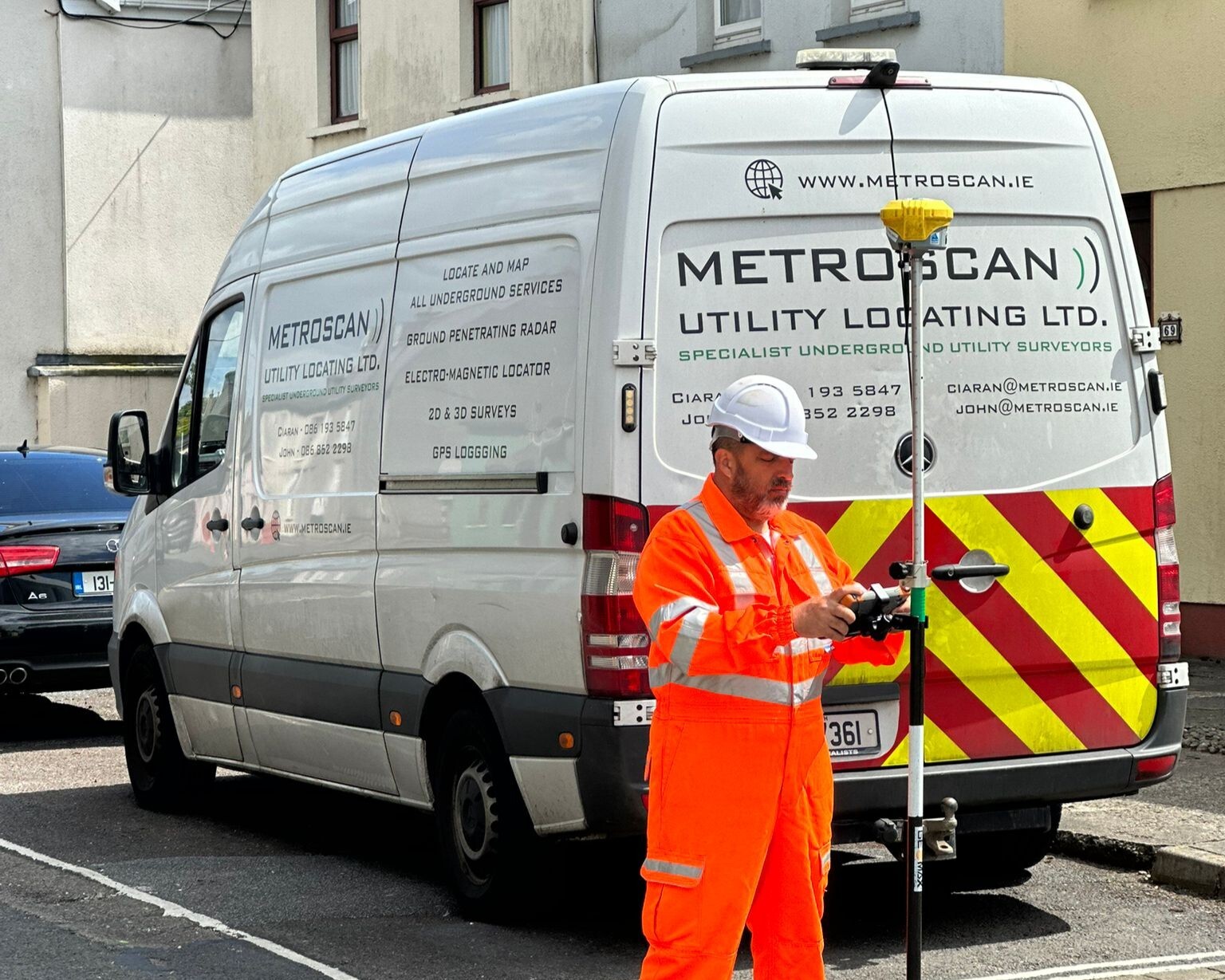
“GeoMax and Hitechniques have been invaluable in helping us integrate GNSS rovers and total stations with our ground-penetrating radar technology. The accuracy and ease of use are unbeatable.” – John Stafford, Director, Metroscan
Dundalk Fabrications: Enhancing Steel Fabrication Processes
Dundalk Fabrications, a specialist engineering company, faced challenges in efficiently transferring data between their design and site teams. Their goal was to improve site surveys and set-out processes.
The Solution: GeoMax Zoom90 robotic total station & X-PAD
- Improved Workflow: Automated data transfer reduced time spent on manual measurements.
- Higher Accuracy: The Zoom90 robotic total station allowed precise layout of structural steel elements.
- Streamlined Communication: X-PAD software enabled real-time synchronisation between teams.
Benefits Realised
With the GeoMax Zoom90, the company eliminated manual errors and improved overall efficiency. The ability to precisely measure and document structural components resulted in smoother communication with design engineers.
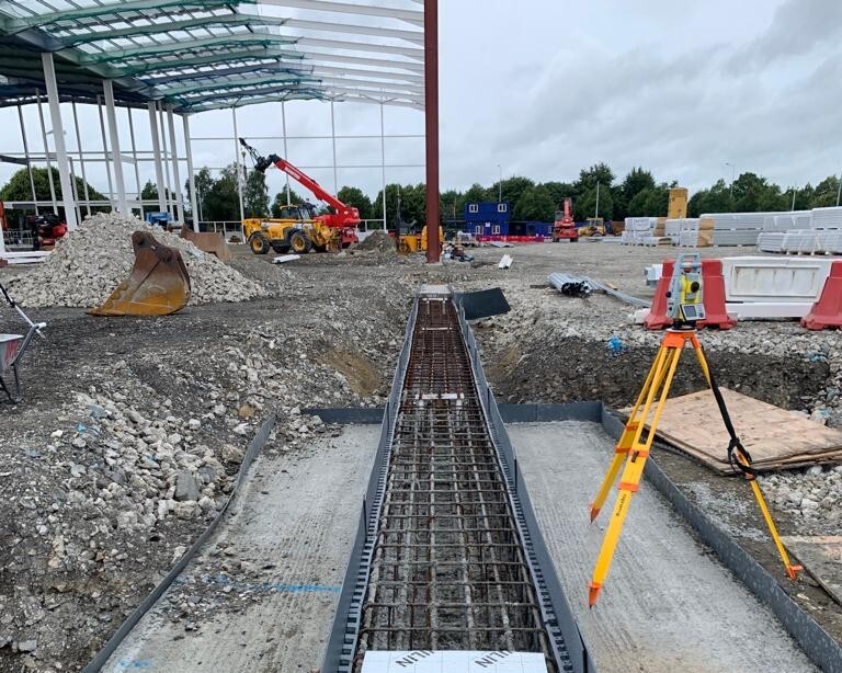
“With GeoMax Zoom90, we can survey existing structures, record finished floor levels, and set out new elements with confidence. The ability to trust our own data to set out the new elements has been a game-changer.” – Eddie McArdle, Site Manager, Dundalk Fabrications
Beausang Plant Hire: Improving Construction Site Efficiency
Beausang Plant Hire & Civil Engineering, based in County Cork, needed a reliable GPS rover for their residential construction projects. After trialling multiple brands, they selected the GeoMax Zenith60 IMU GNSS Rover.
Key Reasons for Their Decision
- Best-in-Class Signal Strength: Consistently strong GNSS signal, even in challenging environments.
- Speed & Usability: Faster and more intuitive than competing solutions.
- Comprehensive Training & Support: Hitechniques provided hands-on training and ongoing technical support.
Why the Zenith60 Stood Out
The GeoMax Zenith60 performed exceptionally well during trials, delivering the highest accuracy and fastest operation time compared to alternatives.
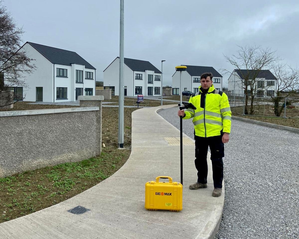
“GeoMax offered the best combination of speed, usability, and accuracy. The support from Hitechniques made the transition seamless.” – Aaron Beausang
BDG Engineering: Transforming Site Surveys with Zenith16 GNSS
Brian Grace, a chartered engineer and owner of BDG Engineering Consultancy, needed a more efficient solution for site mapping and property surveys. Traditional methods were time-consuming, often requiring two days for tasks that could be streamlined with modern technology.
The Solution: GeoMax Zenith16 GNSS
- Significant Time Savings: Surveys that once took two days were completed in just two hours.
- One-Man Operation: Unlike total stations, the Zenith16 allowed Brian to work independently.
- Precision & Confidence: High accuracy for boundary disputes, legal mapping, and property surveys.
The Results
With the Zenith16 GNSS and X-PAD software, Brian dramatically improved his workflow and efficiency. The ease of use and reliable accuracy allowed him to handle more projects without relying on external surveyors.
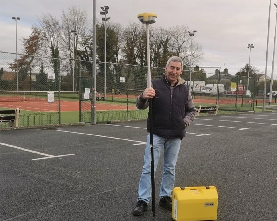
"The Zenith16 has completely changed how I work—it's fast, accurate, and easy to use. I certainly won’t be returning to the old measuring tape!" – Brian Grace, Chartered Engineer
Additional Industry Applications
Beyond the featured case studies, several other industries have seen significant improvements with GeoMax equipment:
- Timber Frame Companies: Use GeoMax total stations for highly accurate structural layout, reducing human error and increasing build efficiency.
- Marine Engineering Professionals: Implement GeoMax GNSS receivers in offshore and coastal projects, ensuring precise measurements for marine infrastructure development.
GeoMax products also offer practical advantages for municipal infrastructure projects, urban planning, and environmental monitoring. The ability to gather and process data accurately ensures that large-scale developments can proceed smoothly, reducing costly errors and project delays.
Why Companies Choose GeoMax and Hitechniques
Hitechniques is an authorised GeoMax dealer in Ireland, providing businesses with:
- Expert Consultation: We help businesses choose the best solutions for their needs.
- Hands-On Training: Customers receive in-depth training sessions on GeoMax products during our obligation-free demos and on delivery day if needed.
- Customer Support: We offer various technical support options to ensure smooth operation.
- Equipment Trials: Businesses can try before they buy, ensuring the right fit for their workflow.
We also provide industry insights and regular software updates to keep customers at the forefront of surveying technology. Whether you're a sole trader or a large enterprise, Hitechniques is committed to your success.
Conclusion: GeoMax surveying equipment
GeoMax surveying equipment has proven to be an invaluable asset across various industries. Whether in utility surveying, steel fabrication, plant hire, or consulting engineering, businesses have experienced significant improvements in accuracy, efficiency, and workflow management.
Through the support of Hitechniques, customers have not only acquired top-tier surveying equipment but also received the training and technical assistance needed to maximise its potential.
If your business is looking to enhance its surveying capabilities, GeoMax solutions—backed by the expertise of Hitechniques—are the perfect choice. Reach out today to learn more about how GeoMax technology can elevate your operations and help you stay ahead in a competitive industry.
Frequently Asked Questions (FAQ)
What industries benefit the most from GeoMax surveying equipment?
GeoMax equipment is widely used in industries such as utility surveying, steel fabrication, civil engineering, construction, land surveying, and marine engineering. The technology helps professionals achieve greater accuracy, efficiency, and workflow optimization.
What is the difference between GeoMax Zenith16 and Zenith60 Pro GNSS receivers?
The Zenith16 is a cost-effective and reliable GNSS receiver suitable for general surveying tasks, while the Zenith60 Pro is an advanced model featuring IMU technology for increased stability, superior signal strength, and operation without the need for calibration.
How do the GeoMax robotic total stations improve surveying?
The Zoom90 and Zoom95 robotic total stations enhance productivity by automating measurements, eliminating the need for manual operation, and integrating seamlessly with design software like AutoCAD and X-PAD.
What is X-PAD and how does it enhance the surveying process?
X-PAD is GeoMax's proprietary surveying software that facilitates real-time data processing, cloud storage, and on-site adjustments. It allows users to streamline operations, minimise errors, and improve accuracy.
What training and support does Hitechniques provide for GeoMax users?
Hitechniques offers hands-on training, on-site demonstrations, and first class technical support to ensure users get the most out of their GeoMax equipment.
Can I test GeoMax equipment before purchasing?
Yes, we offer on-site demonstrations as well as equipment trials so businesses can evaluate different models and select the best fit for their needs before committing to a purchase.
What makes GeoMax different from other surveying equipment brands?
GeoMax stands out due to its ease of use, and cost-effectiveness. Unlike some competitors, GeoMax products offer precision, rugged reliability, and high-end features at a more accessible price point.
How can I purchase GeoMax equipment?
You can contact us to discuss your requirements, schedule a demonstration, or place an order. Our team will guide you in selecting the best surveying solutions for your needs.
Discover precision and efficiency with GeoMax surveying solutions—explore our range and find the perfect fit for your projects.