Creating surfaces with Unicontrol3D machine control software
Posted by Philip Hanrahan B.E., B.A., M.I.E.I.; Brian Mangan B.E. (Agric. Eng.) on 28th Mar 2023
The team at Unicontrol have really thought about their product and the useability of that product for the end user, in this case, the operator of excavators, wheel loaders, dozers, backhoes and finally, their GNSS Rover.
One of my favourite features is the Create Surfaces function, which allows the operator to quickly create a level by themselves using the information given to them on the drawing.
The Create Surfaces feature can speed up the process onsite and reduce the need for the contractor or engineers to provide 3D surface drawings to enable the machine to work. The system is constantly upgrading and meeting the demands of the customers. There are currently four options for creating surfaces. Read below for a quick introduction to these options.
Flat Surface
This option enables the operator to create a flat or level surface at a given elevation. The elevation can be entered by the operator in the app. For example, if the site plans show a FFL (Finished Floor Level), the operator can use this information to create a surface at the given elevation without the need to have an engineer set up a benchmark for them.
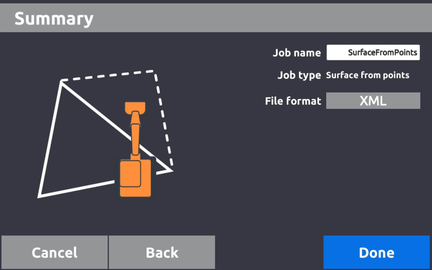
Surface From Points
This option enables the operator to create a surface from pre-surveyed points. Once the operator selects the points, the system automatically triangulates them, forming a surface as an XML surface file.
A simple scenario may be that the machine is excavating a site to formation level and there is a deep cut but there is no surface file on the excavator for the slopes. Using the DXF (linework) drawing the operator can survey points along that line at the desired depth. After the first points are taken at dig level, they can then survey points at the top level, i.e. from the boundary or a line for the top of slope. Once these points are surveyed the operator can then create a surface using the points in the Surface From Points feature.
The surface created this way will give the operator a level to work from with the required slope. This will speed up the productivity of the excavator as the operator will be able to complete the job in 1 pass.
Foundation Outline
This option works similarly to the flat surface. The only difference is that Flat surface is infinite, so wherever we go the level will remain the same.
With foundation outline we log/survey the outline of the foundation of the building and we can limit the surface to a certain distance outside the footing extremities.
E.g. If the machine was working on a building site with different floor levels we can set the foundation outline for each house numbering them as we go, all surfaces will be saved in the history of the project in the jobs menu making it easy to revisit the surface again.
Cross Sectional Surface
This is a new function being released soon that will allow the operator to create simple road designs, ditches, etc. using polylines. This function will create a cross sectional view which will create the surface between the line work and for the length of the linework. It’s a real game changer for anybody using Unicontrol 3D.
Summary
Using machine control will usually boost productivity by 30-50%, allowing machine operators to work independently while reducing the need for a survey engineer.
The operator’s ability to create simple drawings really streamlines the earthmoving aspect on sites. Unicontrol’s surface generation feature boosts productivity even more as the operator can create surfaces of any shape or form independently and accurately, and complete the work in the first pass.
Earthworks should be simple and Unicontrol is making sure that their machine control systems make it possible.
---
We are offering a free 1 month trial of Unicontrol systems. Get in touch with brian@hitechniques.ie to register your interest.